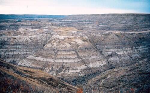

Horseshoe Canyon
Canada
The canyon gets its name from its horseshoe shape, defined by two coulees that flow into the Kneehill Creek, a tributary of the Red Deer River. The canyon's two arms are approximately 5 km long each, extending from Highway 9 to Kneehill Creek, at two former mining communities of Dunphy and Gatine. In turn, it gives the name to the Horseshoe Canyon Formation.
목차
6구간 · 구간을 누르면 글 앞부분이 보여요이 이야기는 영어로 쓰여 있어요. 한국어로 읽고 듣는 것은 앱에서 해요. 앱에서 열기 →
1Horseshoe Canyon
Welcome, observant travelers, to Horseshoe Canyon. As you stand at the precipice of this magnificent U shaped depression, you are looking back in time through the pages of Earth's geological diary. …
앱에서 듣기2The Descent and Stratigraphy
As you navigate the wooden stairs descending into the canyon, you are physically moving backward through time. With every step downward, you pass thousands of years of geological accumulation. …
앱에서 듣기3The Canyon Floor
Now that we have reached the canyon floor, the true scale of this geological amphitheater becomes apparent. You are completely surrounded by the rugged beauty of the badlands. …
앱에서 듣기4The Inner Ravines
Wandering deeper into the branching arms of Horseshoe Canyon, the isolation deepens. The ambient noise from the highway above is entirely absorbed by the thick, earthen walls, leaving a profound and serene silence. …
앱에서 듣기5The Fossil Bearing Strata
As we approach the far end of this accessible ravine, I draw your attention back to the canyon walls, specifically focusing on the paleontology of the Horseshoe Canyon Formation. This geological formation is incredibly rich in…
앱에서 듣기6Horseshoe Canyon
We now begin our ascent, retracing our steps up the wooden staircase to the prairie rim. The climb requires some exertion, a physical reminder of the depth we have explored. …
앱에서 듣기
Horseshoe Canyon은(는) 어떤 곳인가요?
Horseshoe Canyon — Canada에 있는 장소로, 텔비에 이야기 6구간이 있어요. 구간마다 앞부분은 이 페이지에서 글로 읽고, 소리는 앱에서 들어요.
| 위치 | Canada |
|---|---|
| 종류 | 유적 |
| 이야기 구간 | 6 |
| 글 언어 | 영어 |
| 좌표 | 51.4166, -112.8849 |
| 최종 수정 |